


Map Pad GPS Land Surveys & Measurements
Andrzej Bieniek
Deskripsi Map Pad GPS Land Surveys & Measurements
Use MapPad to calculate areas, perimeters and distances - save, export and share your measurements.
MapPad is providing multi-purpose mapping solution allowing location capture and determines distance and area for the shapes drawn on the map or captured using real-time GPS tracking.
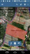
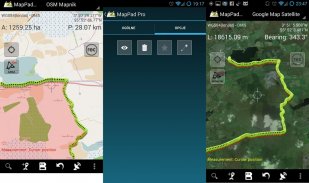
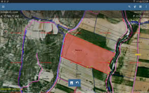
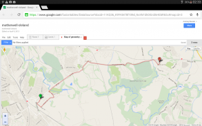
Calculate area of the field or a walk distance instantly using Google or Bing Map Satellite view. Save petrol and time and capture features with few clicks on the map.
Area & Distance measurements are very accurate - please compare with other apps and what's on the ground.
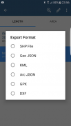
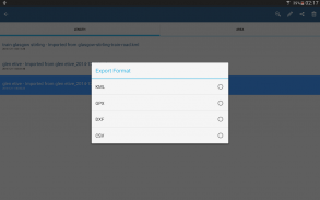
With MapPad you can capture, manage and share your data easily. App supports number of well-known cloud providers like G-Drive, Dropbox and export formats: SHP File, GeoJSON, ArcJSON, KML, GPX, CSV and AutoCAD DXF.
MapPad is a very useful tool for anyone involved in forestry, agriculture (measuring farms, soils, grow, check planted area etc.), roofing, solar panel planning and solar panel installation, fencing, construction, real estate management, asset management, winter snow removal or farming business.
MapPad also can be used in the whole range of outdoor activities like golf (distance meter and range finder), biking, walking, running, jogging and other sports where possibility of measure areas or distances is necessary.
Please visit our website to find out how to prepare offline map and get more information about this product.
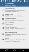
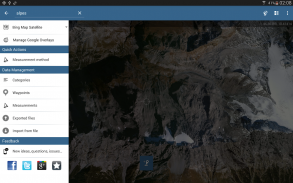
Selected features:
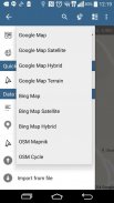
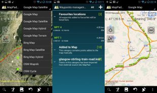
- Base maps: Google Maps (Standard, Satellite, Hybrid, Terrain), Open Street Map (Mapnik, Cycle), Bing Maps (Satellite, Hybrid, Roads).
- Google Maps Overlays (Custom WMS or ArcGIS Server Tiled service), some layers like US Topographic map have been predefined.
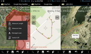
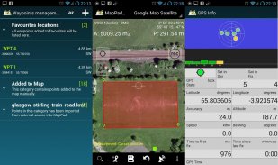
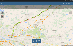
- Very accurate measurement of areas and distances.
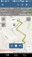
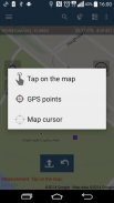
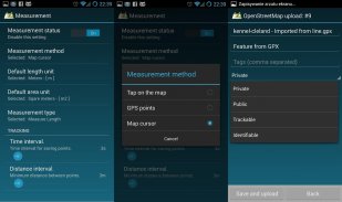
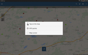
- 3 methods of measurement are supported (Tap on the map, GPS location, Map cursor location).
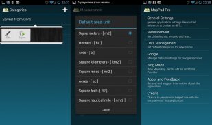
- Support for number of metric and imperial units.
- Support for several global and local coordinate systems: WGS84 (decimal or degrees), Web Mercator, British National Grid, UTM SAD69 (Brazil), UTM NAD83, NATO, Stereo70 (Romania), System 1992 (Poland), Greek Grid – if you require support for any other spatial reference please get in touch.
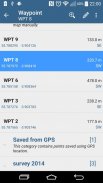
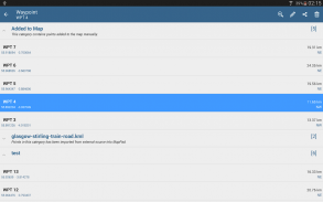
- Possibility to capture waypoints and group them in categories.
- Possibility to add\edit title and description for each recorded measurement and waypoint.
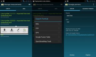
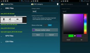
- Export single or multiple measurements or waypoints to SHP File, GeoJSON, ArcJSON, KML, GPX, CSV and DXF to SD Card or cloud services like Fusion Tables, Dropbox or Directly to Open Street Map.
- Share single waypoint location directly by SMS, E-mail or other ways.
- Elevation profile available for measurements done by GPS.
- Import of KML and GPX files to the application.
- GPS status and satellites status.
- Address, location search.
- Quick open exported KML files in Google Earth
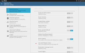
- Ability to set default measurement units, waypoints' categories colours, track recording time and distance interval, transparency of Google Maps overlays and much more...
Please note:
If you experience any problems or have new ideas or comments please do not hesitate to contact us directly or using the contact forms provided on our website. We take your opinion very seriously and do appreciate any form of feedback.
Our users are successfully using MapPad in number of applications including:
- environmental surveys,
- roofing and solar panel planning,
- calculations for snow removal,
- biking and walking routes planning,
- forestry planning and woodland management,
- agriculture and soils' surveys,
- road constructions,
- tree surveys
Gunakan MapPad untuk menghitung daerah, perimeter dan jarak - menyimpan, ekspor dan berbagi pengukuran Anda.
MapPad menyediakan solusi pemetaan multi-tujuan yang memungkinkan lokasi pengambilan dan menentukan jarak dan daerah untuk digambar di peta atau ditangkap menggunakan real-time pelacakan GPS bentuk.
Menghitung luas dari bidang atau berjalan jarak langsung menggunakan Google atau Bing Map tampilan Satelit. Menghemat bensin dan waktu dan menangkap fitur dengan beberapa klik pada peta.
pengukuran luas & Jarak yang sangat akurat - silakan bandingkan dengan aplikasi lain dan apa yang ada di tanah.
Dengan MapPad Anda dapat menangkap, mengelola dan berbagi data Anda dengan mudah. App mendukung jumlah penyedia cloud terkenal seperti G-Drive, Dropbox dan format ekspor: SHP File, GeoJSON, ArcJSON, KML, GPX, CSV dan AutoCAD DXF.
MapPad adalah alat yang sangat berguna bagi siapa saja yang terlibat dalam kehutanan, pertanian (mengukur pertanian, tanah, tumbuh, periksa area tertanam dll), atap, perencanaan panel surya dan instalasi panel surya, pagar, konstruksi, manajemen real estate, manajemen aset, musim dingin salju atau bisnis pertanian.
MapPad juga dapat digunakan dalam berbagai macam kegiatan di luar ruangan seperti golf (meter jarak dan range finder), bersepeda, berjalan, berlari, jogging dan olahraga lainnya di mana kemungkinan daerah ukuran atau jarak yang diperlukan.
Silahkan kunjungi website kami untuk mengetahui bagaimana mempersiapkan peta offline dan mendapatkan informasi lebih lanjut tentang produk ini.
fitur yang dipilih:
- Peta Base: Google Maps (Standard, satelit, Hybrid, Medan), Open Street Map (Mapnik, Cycle), Bing Maps (Satellite, Hybrid, Jalan).
- Google Maps Hamparan (Custom WMS atau ArcGIS Server layanan Ubin), beberapa lapisan seperti peta US topografi telah ditentukan sebelumnya.
- Pengukuran Sangat akurat daerah dan jarak.
- 3 metode pengukuran yang didukung (Tap di peta, lokasi GPS, Peta lokasi kursor).
- Dukungan untuk jumlah unit metrik dan imperial.
- Dukungan untuk beberapa global dan lokal sistem koordinat: WGS84 (desimal atau derajat), Web Mercator, British National Grid, UTM SAD69 (Brazil), UTM NAD83, NATO, Stereo70 (Rumania), Sistem 1992 (Polandia), Yunani Grid - jika Anda memerlukan dukungan untuk referensi spasial lainnya silakan berhubungan.
- Kemungkinan untuk menangkap titik arah dan kelompok mereka dalam kategori.
- Kemungkinan untuk menambahkan \ mengedit judul dan deskripsi untuk setiap pengukuran dicatat dan waypoint.
- Ekspor satu atau beberapa pengukuran atau titik arah ke SHP File, GeoJSON, ArcJSON, KML, GPX, CSV dan DXF ke layanan SD Card atau awan seperti Tabel Fusion, Dropbox atau langsung ke Open Street Map.
- Berbagi tunggal waypoint lokasi langsung oleh SMS, E-mail atau cara lain.
- Profil Elevation tersedia untuk pengukuran yang dilakukan oleh GPS.
- Impor KML dan GPX file untuk aplikasi.
- Status GPS dan status satelit.
- Alamat, pencarian lokasi.
- Terbuka Cepat diekspor file KML di Google Earth
- Kemampuan untuk mengatur unit pengukuran default, titik arah 'kategori warna, track waktu perekaman dan jarak interval, transparansi Maps hamparan Google dan banyak lagi ...
Tolong dicatat:
Jika Anda mengalami masalah atau punya ide atau komentar baru jangan ragu untuk menghubungi kami secara langsung atau menggunakan formulir kontak yang disediakan di website kami. Kami mengambil pendapat Anda dengan sangat serius dan menghargai segala bentuk umpan balik.
pengguna kami berhasil menggunakan MapPad di sejumlah aplikasi termasuk:
- Survei lingkungan,
- Atap dan perencanaan panel surya,
- Perhitungan untuk membersihkan salju,
- Bersepeda dan berjalan perencanaan rute,
- Perencanaan kehutanan dan manajemen hutan,
- Pertanian dan survei tanah ',
- Pembangunan jalan,
- Survei pohon
Use MapPad to calculate areas, perimeters and distances - save, export and share your measurements.
MapPad is providing multi-purpose mapping solution allowing location capture and determines distance and area for the shapes drawn on the map or captured using real-time GPS tracking.
Calculate area of the field or a walk distance instantly using Google or Bing Map Satellite view. Save petrol and time and capture features with few clicks on the map.
Area & Distance measurements are very accurate - please compare with other apps and what's on the ground.
With MapPad you can capture, manage and share your data easily. App supports number of well-known cloud providers like G-Drive, Dropbox and export formats: SHP File, GeoJSON, ArcJSON, KML, GPX, CSV and AutoCAD DXF.
MapPad is a very useful tool for anyone involved in forestry, agriculture (measuring farms, soils, grow, check planted area etc.), roofing, solar panel planning and solar panel installation, fencing, construction, real estate management, asset management, winter snow removal or farming business.
MapPad also can be used in the whole range of outdoor activities like golf (distance meter and range finder), biking, walking, running, jogging and other sports where possibility of measure areas or distances is necessary.
Please visit our website to find out how to prepare offline map and get more information about this product.
Selected features:
- Base maps: Google Maps (Standard, Satellite, Hybrid, Terrain), Open Street Map (Mapnik, Cycle), Bing Maps (Satellite, Hybrid, Roads).
- Google Maps Overlays (Custom WMS or ArcGIS Server Tiled service), some layers like US Topographic map have been predefined.
- Very accurate measurement of areas and distances.
- 3 methods of measurement are supported (Tap on the map, GPS location, Map cursor location).
- Support for number of metric and imperial units.
- Support for several global and local coordinate systems: WGS84 (decimal or degrees), Web Mercator, British National Grid, UTM SAD69 (Brazil), UTM NAD83, NATO, Stereo70 (Romania), System 1992 (Poland), Greek Grid – if you require support for any other spatial reference please get in touch.
- Possibility to capture waypoints and group them in categories.
- Possibility to add\edit title and description for each recorded measurement and waypoint.
- Export single or multiple measurements or waypoints to SHP File, GeoJSON, ArcJSON, KML, GPX, CSV and DXF to SD Card or cloud services like Fusion Tables, Dropbox or Directly to Open Street Map.
- Share single waypoint location directly by SMS, E-mail or other ways.
- Elevation profile available for measurements done by GPS.
- Import of KML and GPX files to the application.
- GPS status and satellites status.
- Address, location search.
- Quick open exported KML files in Google Earth
- Ability to set default measurement units, waypoints' categories colours, track recording time and distance interval, transparency of Google Maps overlays and much more...
Please note:
If you experience any problems or have new ideas or comments please do not hesitate to contact us directly or using the contact forms provided on our website. We take your opinion very seriously and do appreciate any form of feedback.
Our users are successfully using MapPad in number of applications including:
- environmental surveys,
- roofing and solar panel planning,
- calculations for snow removal,
- biking and walking routes planning,
- forestry planning and woodland management,
- agriculture and soils' surveys,
- road constructions,
- tree surveys
Map Pad GPS Land Surveys & Measurements - Versi 7.5.0
(19-05-2019)
Map Pad GPS Land Surveys & Measurements - Informasi APK
Versi APK: 7.5.0Paket: com.osedok.mappadVersi Terakhir dari Map Pad GPS Land Surveys & Measurements
Versi lain


Aplikasi pada kategori yang sama

Anda juga mungkin suka...

Aplikasi pada kategori yang sama


